
A Brief Overview
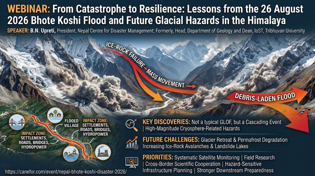
On 26 August 2026, a catastrophic flood struck Nepal’s Bhote Koshi valley, exposing the extreme vulnerability of Himalayan communities, downstream ecosystems, and infrastructure to high-magnitude cryosphere-related hazards. The catastrophe originated near the Nepal-China border in the upper Lhende-Bhote Koshi basin following a major ice-rock mass failure. The collapsed material surged into the valley, generating a massive, highly destructive debris flow laden with water, rocks, and fine sediment that severely damaged settlements, roads, bridges, hydropower installations, and critical border infrastructure.
Keynote Speaker

Prof. Dr. Bishal Nath Upreti
Distinguished Nepalese geologist
Former Head of the Department of Geology and Dean of the Institute of
Science and Technology at Tribhuvan University.
Program Host

Hom Nath Gharti, Assistant Professor
Department of Geological Sciences and Geological Engineering
Queen’s University, Kingston, Ontario, Canada
About the Presenter
Prof. Dr. Bishal Nath Upreti (bnupreti@gmail.com) is a distinguished geologist with over 50 years of experience in Himalayan geological research, authoring over 100 research papers and several books. He serves as President of the Nepal Centre for Disaster Management (NCDM) and was formerly Head of the Department of Geology and Dean of Science and Technology at Tribhuvan University.
A Fellow of NAST, TWAS (UNESCO), and the Zambia Academy of Sciences, Prof. Upreti has held professorships and visiting appointments globally across Asia, Europe, Africa, and Australia. His honors include the TWAS C.N.R. Rao Prize, Honorary Fellowship of the Geological Society of America, the Suprabal Gorkha Dakshin Bahu from the Government of Nepal, and the Toni Hagen Memorial Award.
Key Takeaways
- Cascading Mechanism vs. Single Hazard:
Satellite imagery and initial assessments reveal that the catastrophe was not a conventional Glacial Lake Outburst Flood (GLOF). Instead, it was a complex, cascading high-mountain hazard sequence involving ice-rock structural failure, rapid mass movement, debris transport, and downstream surge flooding. - Amplified Destructive Power:
Interacting cryospheric processes compound in scale, resulting in far greater volume, velocity, and impact than isolated flood or avalanche events. - Cryosphere Degradation Risks:
Widespread glacier retreat, rapid permafrost degradation, and steep rock slope destabilization are lowering structural thresholds across high Himalayan catchments. - Infrastructure Vulnerability:
Modern mountain development—including hydropower projects, border transit corridors, highways, and valley settlements—remains highly exposed to multi-hazard mountain dynamics
Actionable Recommendations & Strategic Priorities
- Systematic Satellite & Earth Observation Monitoring:
Deploy high-resolution, multi-temporal satellite tracking to identify pre-existing slope fractures, destabilized glaciers, and forming barrier lakes before failure occurs. - Field-Based Geological Research:
Conduct targeted geological and geotechnical field surveys to validate remote sensing models and evaluate catchment-scale slope stability. - Cross-Border Scientific Partnerships:
Foster bilateral scientific collaboration across border basins for synchronized monitoring, hazard mapping, and shared flood forecasting. - Enhanced Multi-Hazard Early Warning Systems (EWS):
Transition from single-sensor setups to integrated networks capable of detecting mass failures upstream and alerting downstream settlements in real time. - Hazard-Sensitive Infrastructure Policy:
Revise zoning regulations and engineering codes for hydropower projects, highways, and border infrastructure to account for cascading extreme events. - Community Preparedness & Downstream Resilience:
Build local capacity, conduct emergency response drills, and establish clear evacuation protocols for downstream populations living along vulnerable river corridors.
Platform
Zoom Webinar
Meeting Url: https://uottawa-ca.zoom.us/j/94255989304